![](/images/other/stat-length.png)
![Tour Laufen Le Lude - Le Lude - Luché - Coulongé - Photo](https://media.geolcdn.com/t/1900/400/ext.pjpeg?maxdim=2&url=https%3A%2F%2Fservices.sitytrail.com%2FGeolivesWS%2FDownloadMedia.ashx%3FTrailID%3D102196%26Media%3D2595_1.jpg)
Le Lude - Luché - Coulongé
tracegps
Benutzer
![Länge](/images/other/stat-length.png)
Länge
28 km
![Maximale Höhe](https://static1.geolcdn.com/siteimages/upload/files/1508320355ic_sort_altitude_max_24dp.png)
Maximale Höhe
90 m
![Positive Höhendifferenz](https://static1.geolcdn.com/siteimages/upload/files/1508320355ic_sort_den_pos_24dp.png)
Positive Höhendifferenz
226 m
![Km-Effort](/images/other/stat-length.png)
Km-Effort
31 km
![Min. Höhe](https://static1.geolcdn.com/siteimages/upload/files/1508320355ic_sort_altitude_min_24dp.png)
Min. Höhe
30 m
![Negative Höhendifferenz](https://static1.geolcdn.com/siteimages/upload/files/1508320355ic_sort_den_neg_24dp.png)
Negative Höhendifferenz
231 m
![Boucle](https://static1.geolcdn.com/siteimages/upload/files/16400158638029165_repeat_loop_refresh_sync_direction_icon.png)
Boucle
Ja
Erstellungsdatum :
2014-12-10 00:00:00.0
Letzte Änderung :
2014-12-10 00:00:00.0
![Laufen](https://static1.geolcdn.com/sitytour/trail-icons/103.png)
2h30
Schwierigkeit : Schwierig
![Scannen Sie diesen QR-Code, um die Tour in der SityTrail-Anwendung zu öffnen](https://capi.geolives.com/qq0zvz2zws4bq2lad0pu/sitytour/trails/102196/qr.png?size=200)
Kostenlosegpshiking-Anwendung
Über SityTrail
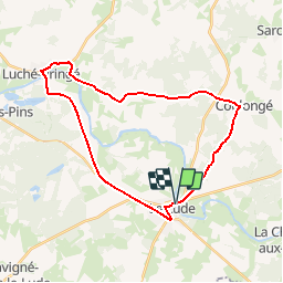
Tour Laufen von 28 km verfügbar auf Pays de la Loire, Sarthe, Le Lude. Diese Tour wird von tracegps vorgeschlagen.
Beschreibung
A partir du Lude, on emprunte la voie verte qui relie Luché Pringé. Bel itinéraire entre forêt et bocage. D’autres infos sur le site des Voies Vertes
Ort
Land:
France
Region :
Pays de la Loire
Abteilung/Provinz :
Sarthe
Kommune :
Le Lude
Standort:
Le Lude
Gehen Sie:(Dec)
Gehen Sie:(UTM)
286727 ; 5281111 (31T) N.
Kommentare
Touren in der Umgebung
![Tour Fahrrad Le Lude - Le Lude - Luché - Coulongé - Photo](https://media.geolcdn.com/t/375/260/ext.jpg?maxdim=2&url=https%3A%2F%2Fservices.sitytrail.com%2FGeolivesWS%2FDownloadMedia.ashx%3FTrailID%3D102197%26Media%3D2595_1.jpg)
![Fahrrad Fahrrad](https://static1.geolcdn.com/sitytour/trail-icons/200.png)
Le Lude - Luché - Coulongé
Fahrrad
Medium
Le Lude,
Pays de la Loire,
Sarthe,
France
![](/images/other/stat-length.png)
28 km | 31 km-effort
1h 30min
![](https://static1.geolcdn.com/siteimages/upload/files/16400158638029165_repeat_loop_refresh_sync_direction_icon.png)
Ja
![Tour Elektrofahrrad Le Lude - Le Lude - La Mans-18745742 - Photo](https://media.geolcdn.com/t/375/260/ext.jpg?maxdim=2&url=https%3A%2F%2Fstatic1.geolcdn.com%2Fsiteimages%2Fupload%2Ffiles%2F1524743154velo.jpg)
![Elektrofahrrad Elektrofahrrad](https://static1.geolcdn.com/sitytour/trail-icons/205.png)
Le Lude - La Mans-18745742
Elektrofahrrad
Sehr leicht
Le Lude,
Pays de la Loire,
Sarthe,
France
![](/images/other/stat-length.png)
51 km | 57 km-effort
Unbekannt
![](https://static1.geolcdn.com/siteimages/upload/files/16400158638029165_repeat_loop_refresh_sync_direction_icon.png)
Nein
![Tour Rennrad Le Lude - 2nov - Photo](https://media.geolcdn.com/t/375/260/ext.jpg?maxdim=2&url=https%3A%2F%2Fstatic1.geolcdn.com%2Fsiteimages%2Fupload%2Ffiles%2F1524743154velo.jpg)
![Rennrad Rennrad](https://static1.geolcdn.com/sitytour/trail-icons/201.png)
![Tour Wandern Le Lude - 2019-08-18 - Photo](https://media.geolcdn.com/t/375/260/ext.jpg?maxdim=2&url=https%3A%2F%2Fstatic1.geolcdn.com%2Fsiteimages%2Fupload%2Ffiles%2F1553511878bg_sport_marche.png)
![Wandern Wandern](https://static1.geolcdn.com/sitytour/trail-icons/101.png)
2019-08-18
Wandern
Medium
Le Lude,
Pays de la Loire,
Sarthe,
France
![](/images/other/stat-length.png)
10,9 km | 12,6 km-effort
2h 58min
![](https://static1.geolcdn.com/siteimages/upload/files/16400158638029165_repeat_loop_refresh_sync_direction_icon.png)
Nein
![Tour Wandern Le Lude - luble - Photo](https://media.geolcdn.com/t/375/260/ext.jpg?maxdim=2&url=https%3A%2F%2Fstatic1.geolcdn.com%2Fsiteimages%2Fupload%2Ffiles%2F1553511878bg_sport_marche.png)
![Wandern Wandern](https://static1.geolcdn.com/sitytour/trail-icons/101.png)
luble
Wandern
Sehr leicht
Le Lude,
Pays de la Loire,
Sarthe,
France
![](/images/other/stat-length.png)
22 km | 25 km-effort
2h 48min
![](https://static1.geolcdn.com/siteimages/upload/files/16400158638029165_repeat_loop_refresh_sync_direction_icon.png)
Nein
![Tour Wandern Le Lude - noyant - Photo](https://media.geolcdn.com/t/375/260/ext.jpg?maxdim=2&url=https%3A%2F%2Fstatic1.geolcdn.com%2Fsiteimages%2Fupload%2Ffiles%2F1553511878bg_sport_marche.png)
![Wandern Wandern](https://static1.geolcdn.com/sitytour/trail-icons/101.png)
noyant
Wandern
Sehr leicht
Le Lude,
Pays de la Loire,
Sarthe,
France
![](/images/other/stat-length.png)
27 km | 31 km-effort
6h 43min
![](https://static1.geolcdn.com/siteimages/upload/files/16400158638029165_repeat_loop_refresh_sync_direction_icon.png)
Nein